ABI198 Section B– Granaries, Bark, and Satellites: An Ever-Evolving Quest
May 7th, 2025
Great job everyone for charging full speed into today's adventures! Looks like our Cahill group was able to find 4 new granaries (7 total) and our Quail Ridge group found 7 new ones (9 total), so the race to find our precious granaries is neck and neck! And a special shoutout to our satellite group for enduring the grueling technicalities of satellite imagery today, whether or not we struck gold.
A lesson we learned today back in Briggs 122 was that there are TONS of ways to go about satellite imagery, with articles left and right outlining the obstacles we may face when attempting such a feat. But any progress is still progress and I feel confident that we will use what we learned today to develop a strong foundation for our image analysis.
And if anyone needs a reminder, the only reason we have an idea light bulb that can spark over our minds is because of the determination of one individual to persevere through the mess of it all:
"I have not failed. I've just found 10,000 ways that won't work"
- Thomas Edison
As a refresher, let's review some of what we know so far:
- Granaries:
- are communal food storage trees used by acorn woodpeckers to store acorns
- consist of hundreds to thousands of small holes to hold individual acorns
- are often found in dead, burned, or mature trees with thick bark
- are often found nearby to acorn food sources (Oak Trees)
- have been observed to be burned Grey Pine Trees during our field sessions
- What we've been measuring:
- Tree Species (Grey Pine vs. Oak)
- GPS coordinates (using Avenza application)
- DBH (Diameter @ Breast Height)
- Fire Severity Score (0-4)
- (Would like to add bark density to this list as a measurement of mass per unit volume)
- A disclaimer for our findings:
- Our granaries aren't entirely independent, meaning that their radii would overlap
- At Cahill some trees were quite close together so we're most likely looking at communities of woodpeckers, not just individual granaries
Here's what we did today:
10:00am – Met with our assigned groups (edited from last Friday's blog:)
- Granary Seekers: Crystal, Stephanie, Amy, Josh, Serenity, Marlee, Ana
- Quail Ridge: Crystal, Stephanie, Amy, Josh
- Cahill: Serenity, Marlee, Ana
- Acorn Analysts: Marshall, Mia, Elizabeth, Megan, Taylor, Arianna, Yusuf, Kelly, Damien
- Cahill
- Satellite Surveyors: Cameron, Ashley, Annika
- Briggs 122
- Burns were superficial at Cahill, while burns at Quail Ridge were more severe
- What could this tell us about bark density, and vice versa? Would more dense trees be less scorched vs less dense trees be more scorched?
- Almost all acorn holes were located on bark plates, not on the furrows between them (see image below for diagram)
- What could this mean for the effects of wildfires on different layers of the trees? Could severely burned furrows be just as optimal for an acorn hole or is there some information the woodpeckers know that we don't? How can we use this finding to further our research?


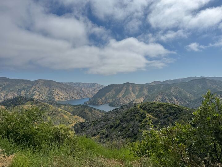
- Our Quail Ridge folks put their hard-earned gator training to great use and found SEVEN new granaries! Way to go! (Plus they had some amazing views along the way)


- And although not as pretty, our satellite team was able to get a ~somewhat~ clear top view of our granaries at Quail Ridge! (One shown here as the tiiiiny red circle in the center of the satellite image)

- What size holes were occupied?
- Is bark thickness the same on all sides of a tree?
- Does bark thickness depend on species?
- Sample 60 holes per tree and do quick measurements on each of the holes at each tree:
- Stratify measurements by cardinal directions and height categories
- 4 directional categories: North South East West (ex: south facing=1 category)
- 3 height categories: 0.5m, 1m. 1.5m
- 5 holes per category (12 categories total x 5 holes = 60 holes)
- Hole measurements
- Hole diameter using calipers
- Acorn status: empty (eaten in place) vs intact (present)
- Greater depth measurements:
- Stand close to the tree at one of the 12 categorical areas (you will need to bend down)
- Point your finger towards the tree, close your eyes, move randomly within the categorical area, and then open your eyes– measure whichever acorn hole your finger is closest to
- Repeat the previous step for all 12 categories
- For each of those 12 holes, here's what we want to measure:
- Collect the acorn (if any) so we can get the mass/dry mass back at the lab
- Acorn length
- Acorn width
- Hole depth: stick something in hole and take it out and measure with calipers
- Bark thickness (need to drill into tree)– 12 times per tree
- We need a fresh hole to get measurement to see living layer
- Neighborhood survey:
- Take a 6-inch PVC square and center it on one of the 12 categories on the tree
- Take a photo of the square and keep these photos organized and labeled
- Count the holes: total occupied AND total unoccupied
- Determine burn severity estimate per square

- 3 more calipers (6 total), so that ~6 teams of 2 can go out into the field and do 2-3 trees per Wednesday session (we need about 1 hr per tree)
- Increment hammer about $160
- Brainstorm how we’re gonna collect and transport bark for bark analysis
- Chisels would be low cost but time consuming and can be unreliable
- Hatchet could work but will mess up the bark, smashes more than cuts
- Increment bores (we have 2)
- Packing tape to put on the bark to cut around so it stays in place even when broken
- Drywall saws to cut around the bark
- Overall figure out how we can get it back intact, maybe wrap in newspaper
- Whether satellite imagery will be a valuable use of our time
- Time consuming and complicated, but could offer potentially useful data
- We will be doing quick presentations on Friday! Each presentation should be as quick as possible, as we will have a packed agenda. The groups will be the same groups we split up into today, and it will just be to briefly go over what you found during today's session (satellite, granary, acorn). The presentations do not have to be completely flushed out, just a general summary of what you found today and anything interesting you'd like the class to know. Here are the presentation requirements:
- 1-5 slides maximum (depends on how much you found)
- Less than 5 minutes for satellite and granary, acorn may be longer to go over protocols
- Include any information you'd like to share about your findings
- 1 question your group has after wednesday's session.
- Each person should find and add at least one (1) paper to the Zotero that can give us information on one or more of the following:
- Bark sampling
- Bark density/thickness and how to measure it
- Anything else you feel could be helpful regarding tree sampling, acorn sampling, satellite imagery, forestry measurements, etc.
- Download ImageJ onto your laptops! If you come across any further issues after following these steps, Cameron has uploaded a doc with more detailed instructions to the shared google drive! The satellite group will also be able to answer any remaining questions on Friday:
- Go to https://imagej.net/ij/download.html
- A zip file should appear in your downloads and when clicking the zip file, a gold microscope icon should then appear in your downloads
- If there is an error message saying you cannot open the file (there will be): Go to your privacy settings on your laptop and there will be a notification when you scroll down (on Mac) that will have a button saying “open anyway”
- Once you allow permissions to “open anyway,” the imageJ server should pop up on screen (it will look like a thin white bar with different icons) and you’re ready to go!
- Bark sampling brainstorm
- Satellite imagery
- Group 1: Establish a complete timeline for the rest of the quarter
- *LAST WEEK IS FOR DATA ANALYSIS ONLY*
- Group 2: Make data sheets (including the one Amy sent into the Slack)
- Quick data
- Slow data
- Neighborhood survey data


Comments
Post a Comment